
The canopy cover atlas is complemented by the Urban Tree Manifesto. It highlights urban trees as critical infrastructure that provides vital climate and well-being benefits. The manifesto contains information on the climate benefits of trees and recommendations on how to take care of the important asset of trees. The message is aimed particularly at residents, for whom trees and the benefits they provide are tangible in their everyday lives.
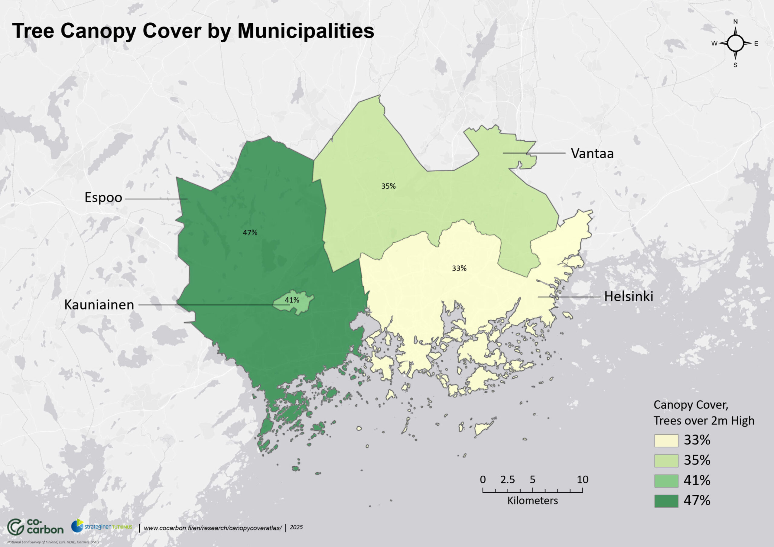
Download here the map Canopy cover by municipalities of the Helsinki Metropolitan Area (as image below).
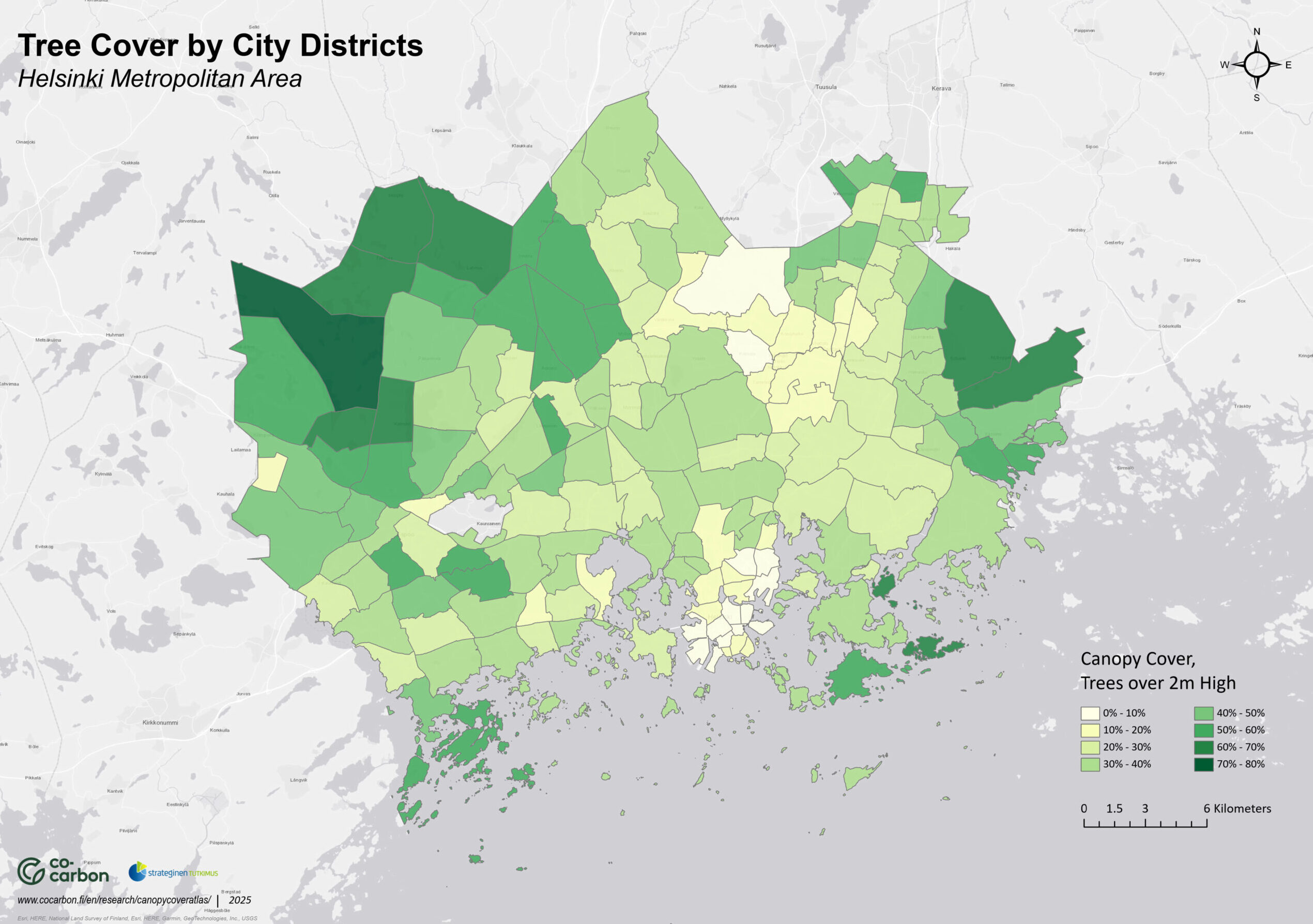
Download here the Canopy cover by city districts atlas of Helsinki, Espoo and Vantaa (the whole as image below). Data considering Kauniainen was not available.
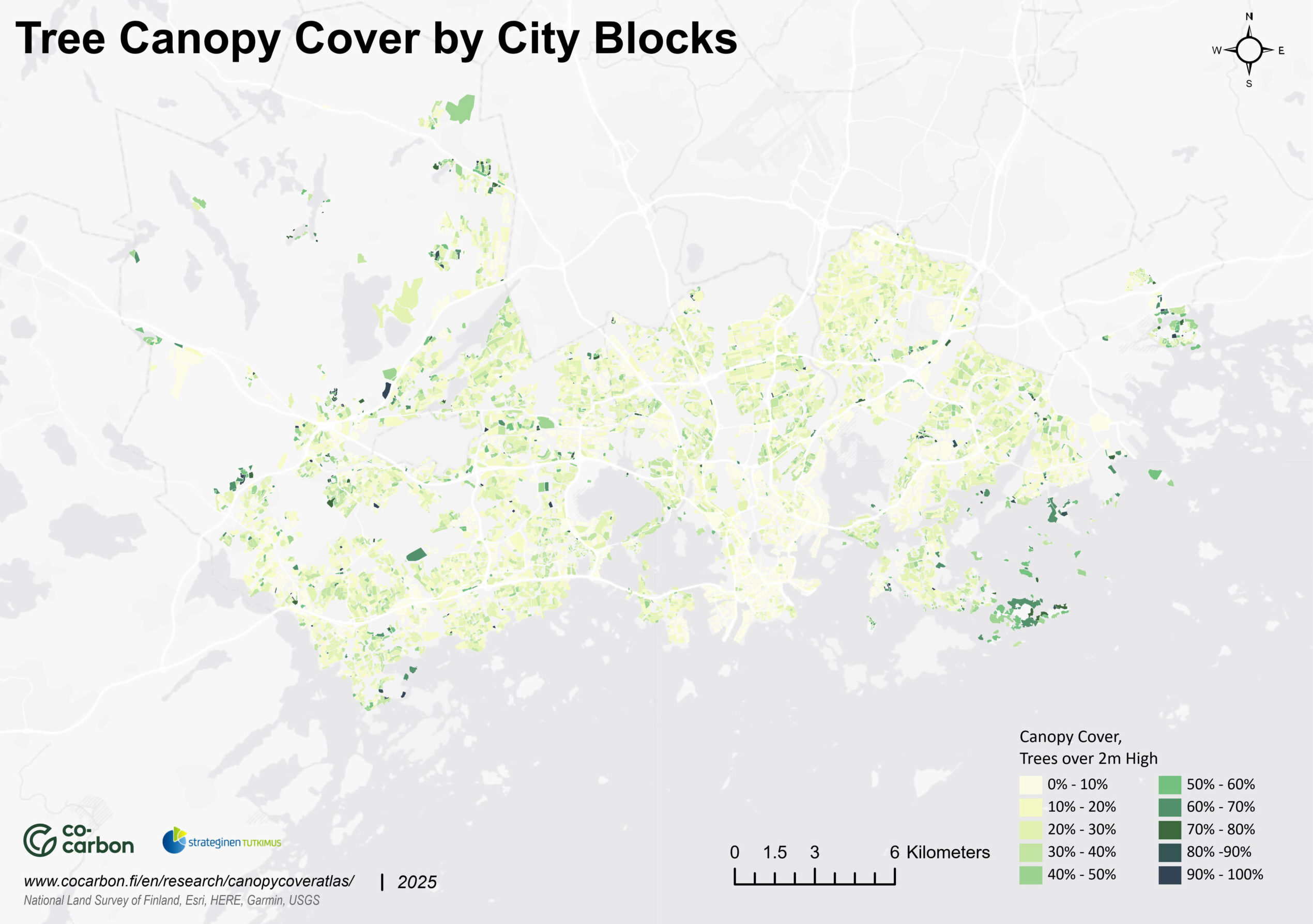
Download here the Canopy cover by city blocks atlas of Espoo and Helsinki (the whole as image below). Data considering other municipalities was not available.
You can also download maps showing one city at a time:
Canopy cover by districts Helsinki
Canopy cover by districts Espoo
Canopy cover by districts Vantaa
Authors: Postdoctoral Researcher Antti Kinnunen and Professor of Landscape Architecture Ranja Hautamäki
Assistant: Syed Peerzada
Check out the Urban Tree Manifesto that complements and explains the atlas!
Come see the large canopy cover map at the Designs for a Cooler Planet exhibition from 5.9.- 28.10!
Data and methods for canopy cover analysis
Canopy cover is a sustainability indicator of green infrastructure that combines many climate and well-being benefits. The importance of the indicator has increased with the European Commission’s Nature Restoration Law, as the regulation requires urban areas to monitor and develop canopy cover. The calculation of canopy cover is based on various spatial data sets or laser-scanned point cloud data. Since there are differences in the accuracy of the data sets, the results of the canopy cover calculation may also vary slightly. Differences also arise from the height of vegetation included in the canopy cover calculation. Some canopy cover calculations use vegetation over 2 meters as a criterion, while others include vegetation over 5 meters, for example. The source data and methods used in this atlas are described below.
Materials used
The work utilized the administrative regional divisions data (NLS 2023) of the National Land Survey of Finland to define municipal boundaries, as well as data available from the open WFS spatial data interfaces maintained by the municipalities of the Helsinki Metropolitan Area to create a hierarchical regional division data describing the variation in canopy cover. The data included the records according to Table 1 for each municipality.
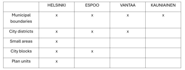
Table 1. Description of the municipal-specific area division and the records it contains. Data sources: City of Helsinki (2025), City of Espoo (2025), City of Vantaa (2025), NLS (2021).
The land cover data produced by the Helsinki Region Environmental Services based on laser scanning from 2024 (HSY, 2025) was used as the canopy cover data. The data is in vector format and the trees are classified by height into 2-10 m, 10-15 m, 15-20 m and over 20 m tall trees. The nominal resolution of the data is 3*3 meters. Trees over 2 meters tall were included in the calculation.
Methods
HSY’s land cover data was rasterized according to the 3*3 meter base raster corresponding to the nominal resolution. After this, the relative shares of canopy cover per area unit were calculated by height class of the stand. These were combined to describe the total canopy cover of the stand.
References
Espoon kaupunki (2025). Espoon kaupunginosajako. Ladattu Espoon kaupungin WFS-rajapinnalta osoitteesta https://kartat.espoo.fi/teklaogcweb/wfs.ashx (luettu 28.3.2025).
Espoon kaupunki (2025). Espoon korttelit. Ladattu Espoon kaupungin WFS-rajapinnalta osoitteesta https://kartat.espoo.fi/teklaogcweb/wfs.ashx (luettu 28.3.2025).
Helsingin kaupunki (2025). Helsingin kaupunginosajako. Ladattu Helsingin kaupungin WFS-rajapinnalta osoitteesta. https://kartta.hel.fi/ws/geoserver/avoindata/wfs (luettu 28.3.2025).
Helsingin kaupunki (2025). Helsingin pienalueet. Ladattu Helsingin kaupungin WFS-rajapinnalta osoitteesta. https://kartta.hel.fi/ws/geoserver/avoindata/wfs (luettu 28.3.2025).
Helsingin kaupunki (2025). Helsingin korttelit. Ladattu Helsingin kaupungin WFS-rajapinnalta osoitteesta. https://kartta.hel.fi/ws/geoserver/avoindata/wfs (luettu 28.3.2025).
Helsingin kaupunki (2025). Helsingin kaavayksiköt. Ladattu Helsingin kaupungin WFS-rajapinnalta osoitteesta. https://kartta.hel.fi/ws/geoserver/avoindata/wfs (luettu 28.3.2025).
Photo: Ranja Hautamäki